What it is
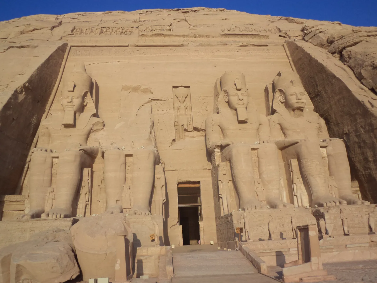
Abu Simbel — Ramesses II's rock temple, the Kadesh reliefs, the solar alignment, and the UNESCO operation that sawed the whole thing into a thousand pieces and rebuilt it higher up.
Built Cut under Ramesses II, c. 1264–1244 BCE; relocated 1964–1968. The principal date, c. 1264–1244 BCE, is range endpoint.
c. 1264–1244 BCE
Cutting the temples
The Great Temple of Ramesses and the smaller temple for Nefertari and Hathor, both cut into the cliff. The twenty-year span is inferred from the reign and from the decoration.
shortly after completion
Earthquake damage
One of the four colossi lost its head and torso in antiquity; the fallen pieces lie at its feet, and they were moved with the rest and replaced where they fell.
antiquity – 1813
Burial and rediscovery
Buried to the shoulders of the colossi by sand. Reported by Johann Ludwig Burckhardt in 1813 and dug open by Giovanni Belzoni in 1817.
1964–1968
Relocation
The whole complex was cut into blocks and rebuilt on higher ground before the reservoir of the Aswan High Dam covered the site.
Who ordered it built
Each attribution carries what supports it. Ancient buildings are routinely credited to people on the authority of writers centuries later, and that is not the same claim as an inscription on the building.
- Evidence level: Documented
Commissioned by
Ramesses II
His cartouches, colossi and dedication texts throughout both temples.
- Evidence level: Unknown
Architect
Unknown
No name survives. The viceroy of Kush Iuny and other officials are named in the temple as having overseen work; that is administration rather than design.
What it was for
A rock-cut temple of Amun-Re, Re-Horakhty, Ptah and the deified Ramesses himself, on the Nile in Nubia, several hundred kilometres upstream of the Egyptian heartland.
The king is one of the four gods seated in the sanctuary. That is the point of the building: it is where Ramesses II is worshipped as a god in his own lifetime, at the frontier, facing the people the temple is addressed to.
How it was built
The temple is subtractive: there is no masonry in the ancient building at all. Everything — the façade, the colossi, the pillared halls, the sanctuary — was cut out of the cliff, working inward, which means every error is permanent.
The interior follows the Egyptian pattern of diminishing height and light: a first hall with eight Osiride pillars of the king, a second smaller hall, a vestibule, and a sanctuary with four seated figures.
The relocation reversed the process. The rock was consolidated with resin, sawn into numbered blocks with hand saws to keep the cuts thin, lifted, stored, and reassembled on a concrete frame inside two artificial domes; a hill was then built over them. The joins are visible on close inspection and were deliberately not disguised.
Materials
- Evidence level: Documented
Nubian sandstone
The living rock the temple is cut into
- Evidence level: Documented
Concrete and steel
The two artificial domes built in 1968 to carry the hill above the relocated temples
- Evidence level: Documented
Synthetic resin
Injected into the friable sandstone before cutting, to hold the blocks together during the move
Measured
Every figure states what it rests on. A modern survey, an ancient text, a conversion from an ancient unit and a modern estimate are four different kinds of statement and are not interchangeable.
The colossi
about 20 m tall, seated
Modern survey.
Depth of the temple into the rock
about 60 m
Modern survey along the axis from the façade to the sanctuary.
Blocks cut for the move
over a thousand, weighing up to about 30 tonnes
The engineering record of the 1964–68 operation.
Distance moved
about 200 m back and 65 m up
The engineering record of the relocation.
What it meant
The temple is a frontier statement. Four colossal seated kings face the river on the Nubian side of the border, in a land Egypt controlled and taxed, with the king among the gods inside. Anyone travelling downstream met it before they met Egypt.
The north wall of the great hall carries the fullest of the Kadesh reliefs: the camp, the Hittite chariots, the king alone in his chariot. Ramesses published the same battle at Karnak, Luxor, Abydos, the Ramesseum and here — five monumental versions of an engagement the Hittite record and the surviving treaty describe as a draw.
The relocation is a political event in its own right. It was the founding project of UNESCO's international campaigns, funded by fifty countries, and it established the idea that a monument could be world heritage with a claim on resources beyond the state that holds it.
Twice a year the sun reaches down the sixty-metre axis and lights three of the four seated figures in the sanctuary; Ptah, a god of the underworld, is left in shadow. The alignment is deliberate and it is one of the few Egyptian solar alignments that is beyond argument.
The relocation shifted the dates. The temple now faces the sun on days about one day later than it did on its original site, which is the price of moving it and is documented in the engineering record.
After antiquity
Buried by sand, which preserved the interior. Belzoni's clearance in 1817 opened it; the temple was a fixture of Nile travel thereafter.
The Aswan High Dam, begun in 1960, would have submerged both temples. The rescue ran from 1964 to 1968 under UNESCO with an international engineering consortium, and a great many other Nubian monuments were moved, given away to foreign museums, or lost.
Condition today
Moved from its site
Complete, and standing sixty-five metres above and two hundred metres behind its original position, inside an artificial hill. Everything a visitor sees is ancient stone in its ancient relative arrangement; the mountain around it is 1960s concrete.
The 1964–68 operation is the reference case for monument relocation. The saw cuts follow the joints of the decoration where possible, the blocks were numbered and recorded, the reassembly reproduced the original spacing and the original relationship to the sun, and the domes carrying the hill are engineered to be inspectable.
The temples were never excavated in the ordinary sense; they were cleared of sand. The relocation, by contrast, produced a complete record of the fabric, since every block was documented as it was cut.
Other Nubian monuments moved in the same campaign went to Madrid, Turin, Leiden and New York as gifts to contributing states. The dispersal is documented and is part of the campaign's history.
Scattered fragments
What has left the building, and where it is now. Where a holding is contested, the museum page says so.
- Evidence level: Documented
Nubian temples relocated or given to contributing countries during the campaign, including the Temple of Debod in Madrid and the Temple of Dendur in New York
Madrid, Turin, Leiden and New York
Not fragments of this temple, but the same operation and the same decision.
Written about in antiquity
Ramesses II, The Kadesh inscriptions Abu Simbel, north wall of the great hall
The Poem and the Bulletin, with the reliefs of the camp and the battle. Ramesses' account of 1274 BCE, published here in its fullest visual form.
The Egyptian–Hittite treaty Karnak and Boğazköy copies
The peace concluded some sixteen years after Kadesh, surviving in Egyptian and Hittite versions. The two texts differ in whose initiative the peace was, which is the clearest available demonstration of how royal records work.
Still argued
By how much did the move shift the solar alignment?
The relocated temple is aligned so that the sun reaches the sanctuary on days close to the original ones; the usual statement is a shift of about a day. Some accounts give no shift and others give more, and the discrepancy comes from how the original dates were themselves calculated. The engineering record of the relocation is the authority, and popular accounts frequently are not.
How to read the evidence labels
- Evidence level: Documented
- Supported by a named primary text or by excavated material evidence.
- Evidence level: Probable
- Supported by strong inference that most specialists accept.
- Evidence level: Disputed
- Substantial specialist disagreement exists; competing readings are stated.
- Evidence level: Literary
- Belongs to poetic or mythological construction rather than to history.
- Evidence level: Mythological
- Belongs to shared religious or mythic tradition rather than to any single text.
- Evidence level: Unknown
- The available evidence is insufficient to decide.
These labels describe the status of the evidence, not our confidence in a conclusion. A claim marked Literary is not a claim we doubt; it is a claim about what kind of thing a poem is.